Geography
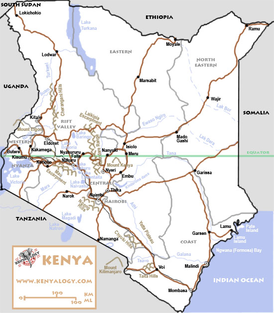
Map
General facts
Location and borders:
East Africa, bordering the Indian Ocean and Lake Victoria (536 km), Somalia (682 km), Ethiopia (861 km), South Sudan (232 km), Uganda (933 km) and Tanzania (769 km). The Ilemi triangle bordering South Sudan is in dispute and has been administered by Kenya since colonial times. Total land boundaries: 3,477 km.
Geographic coordinates:
1 00 N, 38 00 E
Area:
580,370 km² (224,081 sq miles), 49th in the world, slightly more than twice the size of Nevada.
Land: 569,140 km².
Water: 11,227 km².
Highest point:
Peak Batian, Mount Kenya, 5,199 m (second highest summit in Africa).
Lowest point:
Indian Ocean, 0 m.
Main rivers:
Tana and Galana. Both rise in the Highlands and die in the Indian Ocean.
Natural hazards:
Recurring drought, and flooding during rainy seasons. The last volcanic eruption was in 1921 in the Barrier, south of Lake Turkana, elevation 1,032 m. The only other active volcano is South Island in Lake Turkana.
Environmental issues:
There is water pollution from urban and industrial wastes, and degradation of water quality from increased use of pesticides and fertilizers. In Lake Victoria there is water hyacinth infestation which sometimes hinders navigation. Throughout the country there is deforestation, soil erosion, desertification and poaching.
Lake Victoria basin (Nyanza)
The Lake Victoria basin is a plateau located in the southwestern end of the country, in the administrative region corresponding to the Nyanza (lake in Swahili) and Western provinces. The plateau extends northward to the Cherangani Hills at the north east, in the western edge of the Rift Valley, and to Mount Elgon (4,321 m), in Ugandan territory. Southward, the plateau is bordered at the east by Mau Escarpment and reaches the shores of Lake Victoria, 1,200 m above sea level.
The most important city in this region is Kisumu, at the banks of Winam Bay, in Lake Victoria. The town is the third largest in the country, capital of the Luo people and of the Nyanza province. The lake, the third largest in the world with an approximate surface of 68,000 km², is actually an inland sea shared by Kenya, Uganda and Tanzania.
The typical Highlands vegetation is found on most part of this territory. At the slopes of Mount Elgon there are still some patches of tropical rainforest.
Rift Valley & Highlands
The Rift Valley, the great African fault, is a huge scar that crosses from north to south through the eastern half of Africa and the Middle East. Along its enormous depression, the earth is patched with extinct or inactive volcanoes alternating with tectonic lakes.
From the Turkana (formerly Rudolf), in the northern frontier, to the Natron, in Tanzania, the Kenyan Rift comprises a string of small lakes: Baringo, Bogoria, Nakuru, Elmenteita, Naivasha and Magadi.
The large central plateau, the Highlands, is divided by the fault in two parts. At the western edge, the Mau Escarpment rises from the Tanzanian border up to the Cherangani Hills, which fence the plateau that extends itself to the slopes of Mount Elgon. At the east side of the Rift, the Aberdare Range is backed by the Ngong Hills, southwest of Nairobi, and northward to Laikipia Escarpment.
The Eastern Highlands are dominated by the massive Mount Kenya, the highest in the country and the second in Africa. At its snowy heights there are glaciers and three outstanding peaks, Lenana (4,985 m) and the twin Nelion (5,188 m) and Batian (5,199 m).
This region comprises the provinces Rift Valley and Central, and the Nairobi area. Two major cities are here: Nairobi, the capital, and Nakuru, the country's fourth city, next to the lake of the same name. The Highlands' moderate climate and fertile valleys attracted the settling of the first pioneers.
The savannah, the most typical landscape in this part of the world, is actually a transition between rainforest and the arid steppe, and its origins as a natural or a man-made ecosystem are controversial. It is mainly a gramineae grassland dotted with trees and bushes. The savannah's natural balance is achieved by the regular rainfall pattern, which promotes the growth of grass; the migrations of large herds of herbivores seeking the young salt-rich pastures; and fires that prevent the overgrowth of trees and bush that would compete with grass for sunlight and soil nutrients.
Species of the 'Acacia' genus, belonging to the Mimosa family, growing as trees or bushes, are the most common and typical in the savannah. Acacias are easily distinguished by their flat tops, their hard thorns, their composed leaves, their cylindrical clustering flowers and their leguminous-like fruits. Their bark is rich in tannin and is used for manufacturing dies and pharmaceutical products. The acacia is a favourite food for several animal species, such as giraffes, elephants and gerenuks.
The Highlands above 4,000 ft (1,300 m) preserve the richest areas of rainforest in Kenya, although they do not exceed a 3% of the country's area. The largest patches are in Mount Kenya region. Ferns, Mediterranean cedars, junipers and conifers of the 'Podocarpus' genus are widely present. Bamboo forests are found above 6,500 ft (2,000 m). At higher elevations, above 10,000 ft (3,000 m), mountain vegetation sets in with heathers, peat bogs, montane prairies and giant lobelias.
Eastern Highlands (Nyika), North & North East
The vast and arid region that extends to the east of the Highlands includes the provinces Eastern, North Eastern, and part of the Coast province. This plateau, descending smoothly to the shores of the Indian Ocean, displays a smooth orography, only interrupted by isolated low hill assemblies. Their main geographic features are in the zone of Tsavo: the Taïta Hills, to the west of Voi, and the Chyulu Hills, that run in parallel to the railway and the Nairobi-Mombasa highway, the main communication channels between the coast and the inlands.
Tana and Galana, the two main rivers, flow through these lands. Both rise in the Eastern Highlands and die at the Indian Ocean. The Galana originates by the confluence of Athi and Tsavo.
The scarce rainfall registered in this region, together with the high temperatures, determine an uninhabited and semidesert landscape, that becomes a true desert in the most northern areas, next to the shores of Lake Turkana. The dryness of the landscape, sometimes covered with impenetrable thornbush, only finds relief down the fertile river banks and up the green slopes of Taïta Hills.
The presence of a large number of extinct volcanoes is visible in lava currents like the Yatta Plateau, the longest lava stream in the world.
Vegetation is sparse and consists mainly of dry thornbush. In the south area there are acacias and tree cacti of the 'Euphorbia' genus. The giant baobabs ('Adansonia digitata') of the 'Bombacacea' family outstand for their spectacularity, sometimes growing to 60 ft (18 m) high and with trunks reaching 30 ft (9 m) in diameter. Their long and pulpy fruits are good for eating, and the bark is used for manufacturing ropes and cloth.
Plants are more diverse and abundant only at watering holes in the north and northeast, in the river valleys and in areas such as Taïta Hills, with an alpine-like landscape.
Given the extension of the arid regions, the biggest part of Kenya's land consists of deserts or semi-deserted steppes.
Kenya's coast
The Kenyan coastal strip is a plain limited towards the inland by the smooth hills that serve as a gateway to the Highlands. The white sandy beaches, lined by coconut palms, and their crystal water coves are protected of the surge and the currents fromthe East Indian by coral reefs, with an amazing biological wealth which is protected in several marine national parks.
The Ngwana Bay, formerly called Formosa, bears the mouths of the rivers Tana and Galana, the first in its northern end and the second in the south, near the city of Malindi. Several islands rise along the coast, like the Lamu archipelago and the island of Mombasa, the second main city in the country and the coast's capital.
The Kenyan coast, warm and hospitable, was colonized from ancient days by numerous peoples that left their tracks throughout history. The Swahili culture, a blend of Bantu roots with Arab influence, thrived at this coast until reaching a great development before the arrival of the first European explorers.
The temperature and humidity conditions make this region the suitable habitat for tropical vegetation. Mangroves and coconut palm trees grow along the shores and there are still some patches of tropical rainforest.
|