Parks & reserves: Arabuko Sokoke Forest Reserve
Access
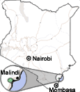
Arabuko Sokoke is located 120 km north of Mombasa along the coastal highway, the B8 heading for Malindi. After passing Kilifi, cashew trees bordering the road reveal one of the region's wealth sources, the cashew factory at Kilifi. Driving away from the town, rubber trees announce the upcoming forest. The gate to the park is located in a detour left from the main road, 1.5 km before the road to Watamu and Gedi. The Arabuko Sokoke Kenya Wildlife Service's office is located nearby. The park's tracks may be explored on foot after the lead of a park's naturalist. It is advisable to appoint the visit the day before and to start the walk early in the morning.
To visit the reserve, the best way is to take the C109 from Malindi, the road that leads eastward to Tsavo East national park. The route can be followed by car, by bicycle (one hour), by bus (one daily) or by matatu (several daily). The reserve's tracks are passable by car, on foot or riding a mountain bike, although some stretches are sandy and pedaling becomes almost impossible. It is necessary to carry water supplies.
From the C109 there are two tracks that cross the forest to end in the coastal highway Kilifi-Malindi, the B8. The C109 gets close to the Galana/Sabaki river banks before entering the Arabuko Sokoke forest. The first track starts in the town of Kakayuni, 12 km off Malindi, covering a 10 km route before dying in the main road. This track traverses through marginal forest lands, making it less interesting. The second track leaves the C109 just before reaching the town of Jilore, located above a bent of the Sabaki/Galana river, 20 km away from Malindi. Past the Jilore Forest Station, a couple of kilometers ahead, there is a detour left which covers 16 km before exiting to the B8 road, 5 km south of Gedi and 2 km south of the Kakayuni track.
|